February 21, 2023

We are happy to announce the release MudShark version 9, now available to all our customers within Software Assurance, or those with an active MudShark Subscription.
Brightbox Software have created a video alongside this blogpost that outlines some of the most important new features in this new release which you can see below
.
Depth Categories
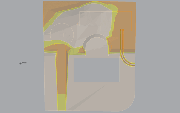
Depth Categories is a feature that we have wanted to introduce for a while, and it’s now included in MudShark version 9. When you go to calculate your project in MudShark you will notice a new checkbox option to calculate the Depth Ranges. If enabled, MudShark will generate a map of your site separated by Depth Range.
Depth Range values are determined by what Profile is selected, by default the 3 most used formats are defined: ARM4, NRM2 and SMM7. You can configure your own Depth Category Profiles if required.

An example of generated Depth Category data.
If you are unfamiliar with the term “Depth Category”, imagine a heatmap where you are separating areas based on predefined values e.g.
Depth Range one: 0m – 2m
Depth Range two: 0m – 4m
Depth Range three: 0m – 4+m
Improved Plan Management

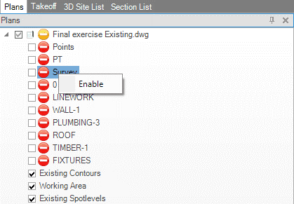
Utilizing the new Plan Management features in MudShark 9
Over the years, as MudShark has been evolving, we noticed our users creating larger and more ambitious projects than ever before. One limiting factor when creating large projects is the number of plan files that need to be imported into MudShark, eventually impacting graphical performance.
To help manage this, we have created a way for users to disable plan layers that are not relevant to MudShark take-off. This can be useful if you only need to see the information from specific layers on the plan (e.g. Contours, Spot Elevations, Bore Points, Structure Boundaries etc.).
To achieve this, simply right click on a plan layer and click the option “Disable” from the dropdown menu to disable a layer. Alternatively, you can disable an entire plan if you no longer need it by right clicking on the plan itself and clicking “Disable”. This process does not delete the plan and, as such, all plan layers can be re-enabled at any time.
Transmute Chain & Split Boundary

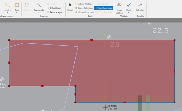
Using the new Split Boundary tool in MudShark
In MudShark version 9, you now have the ability to split boundaries using the Split Boundary too. You no longer need to retrace entire boundaries to edit or remove small sections of a structure. Simply select the boundary you wish to split, then input your cutting line.
Transmute Chain is another tool that can save some time, especially when dealing with messy plan data. It functions similarly to the Transmute Dashed tool but gives you more control over the pathfinding process. This can eliminate issues where the algorithm incorrectly assumes something to be a contour / boundary line.
And More!
With MudShark 9 we have improved a lot of systems behind the scenes, improving speed and robustness of our calculation engine. We have also laid the groundwork for some more big features we are not quite ready to talk about but keep an eye out for future developments.
As previously mentioned, MudShark 9 is available now for any customer with an active subscription or Software Assurance agreement. If you have any queries on the update, please contact our support team at support@bsssoftware.com
If you do not have an active subscription or Software Assurance agreement and you are interested in updating, send us an email at sales@bsssoftware.com and we will arrange a quote.
Cubit Estimating
Cubit Select
Mudshark
More Articles
Driving the next industrial revolution at the GEO Business Show
[fusion_builder_container hundred_percent="no" equal_height_columns="no" menu_anchor="" hide_on_mobile="small-visibility,medium-visibility,large-visibility" class="" id="" background_color="" background_image="" background_position="center center"...
Using earthworks software to make trenching simple
Earthworks estimating software have been developed to help make calculating cut and fill measurements and trench and pipe networks less daunting! It’s never been easier to accurately calculate cut and fill results and see trench measurements. The industry’s...
5 technology innovations in construction
Technology is constantly advancing and as changes continue rapidly it can be hard to keep up to date with the new innovations being introduced. 5 technology innovations in construction that may have an impact on your business: 1. Earthworks Estimating Software...
